JOURNEY / REVELATION
THE SEVEN
CHURCHES
Maps of the cities Revelation was written to
Tap any map to open it full size.
The journey
Seven cities, seven churches / Revelation 1:9–11; chapters 2–3
 Full size
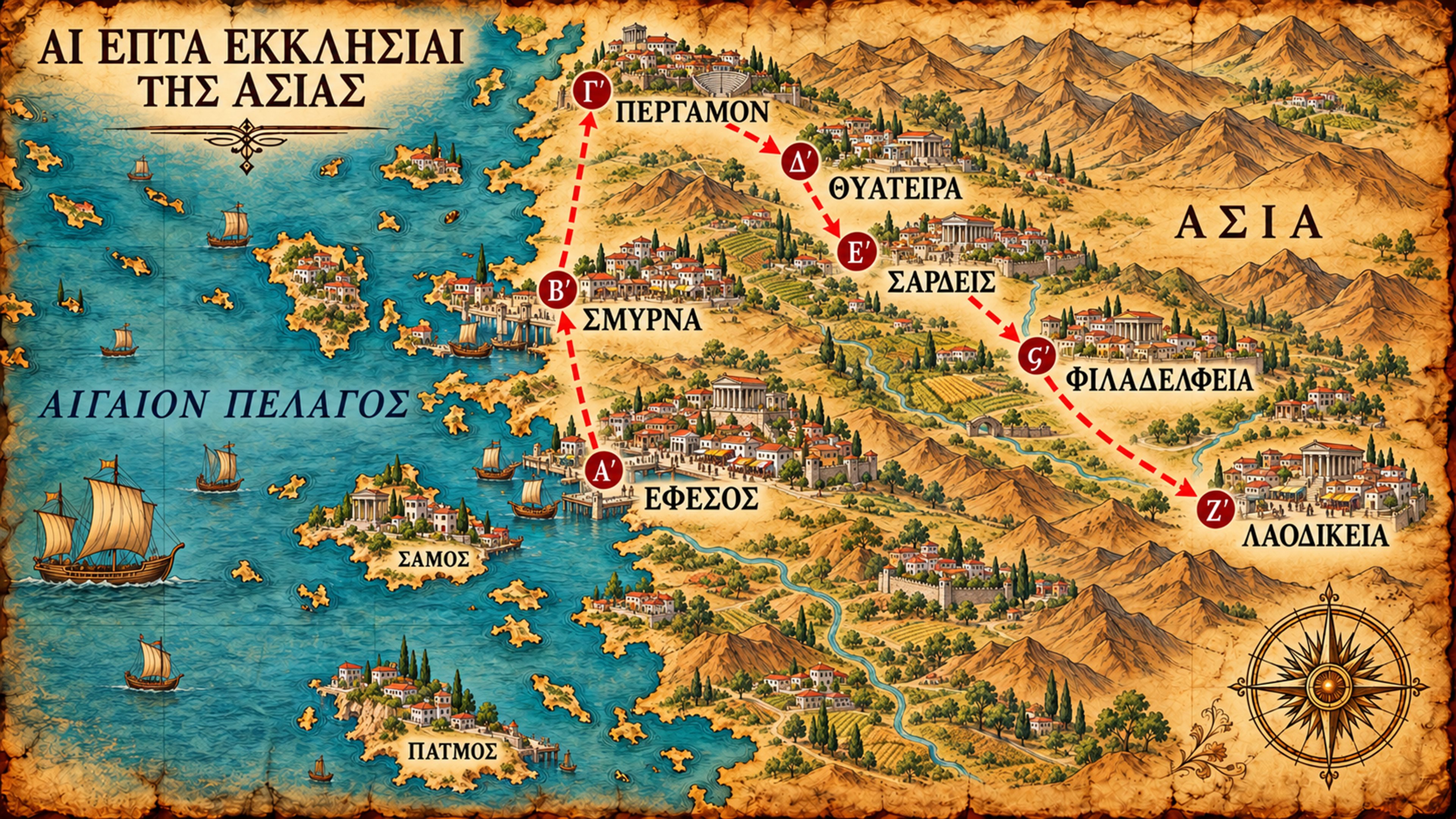
Revelation was written to seven real congregations in the Roman province of Asia, in what is now western Turkey. John received the vision on the island of Patmos and was told to send it to these churches (Revelation 1:9–11). The map follows the order of the letters: Ephesus, Smyrna, Pergamum, Thyatira, Sardis, Philadelphia, and Laodicea.
The red line runs north up the coast from Ephesus to Pergamum, then turns inland through Thyatira, Sardis, and Philadelphia to Laodicea. The harbors, workshops, markets, farms, and public buildings on the map are the kind of places these Christians lived and worked in.
Look closely. Patmos, where John saw the vision, is offshore. Samos is marked to help place the islands. The numbers start at Ephesus.
| ΑΙ ΕΠΤΑ ΕΚΚΛΗΣΙΑΙ ΤΗΣ ΑΣΙΑΣ | The seven churches of Asia |
| Αʹ · ΕΦΕΣΟΣ | 1 · Ephesus |
| Βʹ · ΣΜΥΡΝΑ | 2 · Smyrna |
| Γʹ · ΠΕΡΓΑΜΟΝ | 3 · Pergamum |
| Δʹ · ΘΥΑΤΕΙΡΑ | 4 · Thyatira |
| Εʹ · ΣΑΡΔΕΙΣ | 5 · Sardis |
| Ϛʹ · ΦΙΛΑΔΕΛΦΕΙΑ | 6 · Philadelphia |
| Ζʹ · ΛΑΟΔΙΚΕΙΑ | 7 · Laodicea |
| ΠΑΤΜΟΣ | Patmos |
| ΣΑΜΟΣ | Samos |
| ΑΣΙΑ | Asia — here, the Roman province |
| ΑΙΓΑΙΟΝ ΠΕΛΑΓΟΣ | Aegean Sea |
The letters with a numeral mark represent numbers. The sixth is stigma, Ϛʹ, whose curled form appears on the map. This key also serves the lighter Greek journey map.
Ephesus
A harbor, a theater, a temple / Revelation 2:1–7; Acts 19:24–29
 Full size
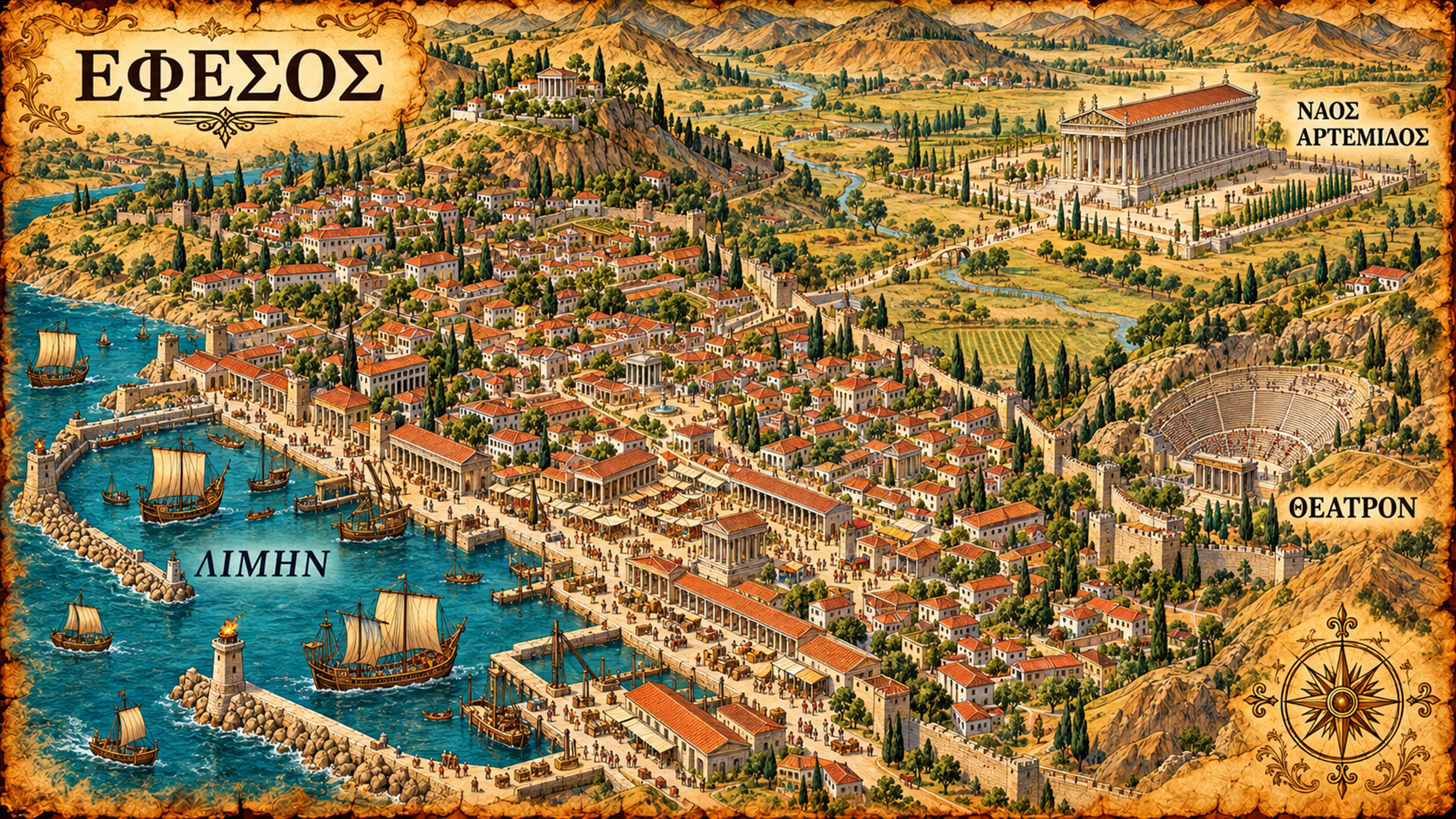
The map shows three things Ephesus was known for: its harbor, the great theater on the hillside, and the Temple of Artemis in its own sanctuary outside the crowded city. Ships brought people and goods in through the harbor, and the streets ran from the waterfront into the city.
Acts 19 shows how trade and worship were tied together there. Demetrius, a silversmith, made silver shrines of Artemis. When Paul's preaching hurt his trade, a crowd rushed into the theater (Acts 19:24–29).
Look closely. The road crosses open ground to the sanctuary of Artemis. The temple stood in its own precinct, apart from the harbor city.
| ΕΦΕΣΟΣ | Ephesus |
| ΝΑΟΣ ΑΡΤΕΜΙΔΟΣ | Temple of Artemis |
| ΛΙΜΗΝ | Harbor |
| ΘΕΑΤΡΟΝ | Theater |
ΝΑΟΣ means "temple"; ΑΡΤΕΜΙΔΟΣ means "of Artemis."
Smyrna
From the harbor to the heights / Revelation 2:8–11
 Full size
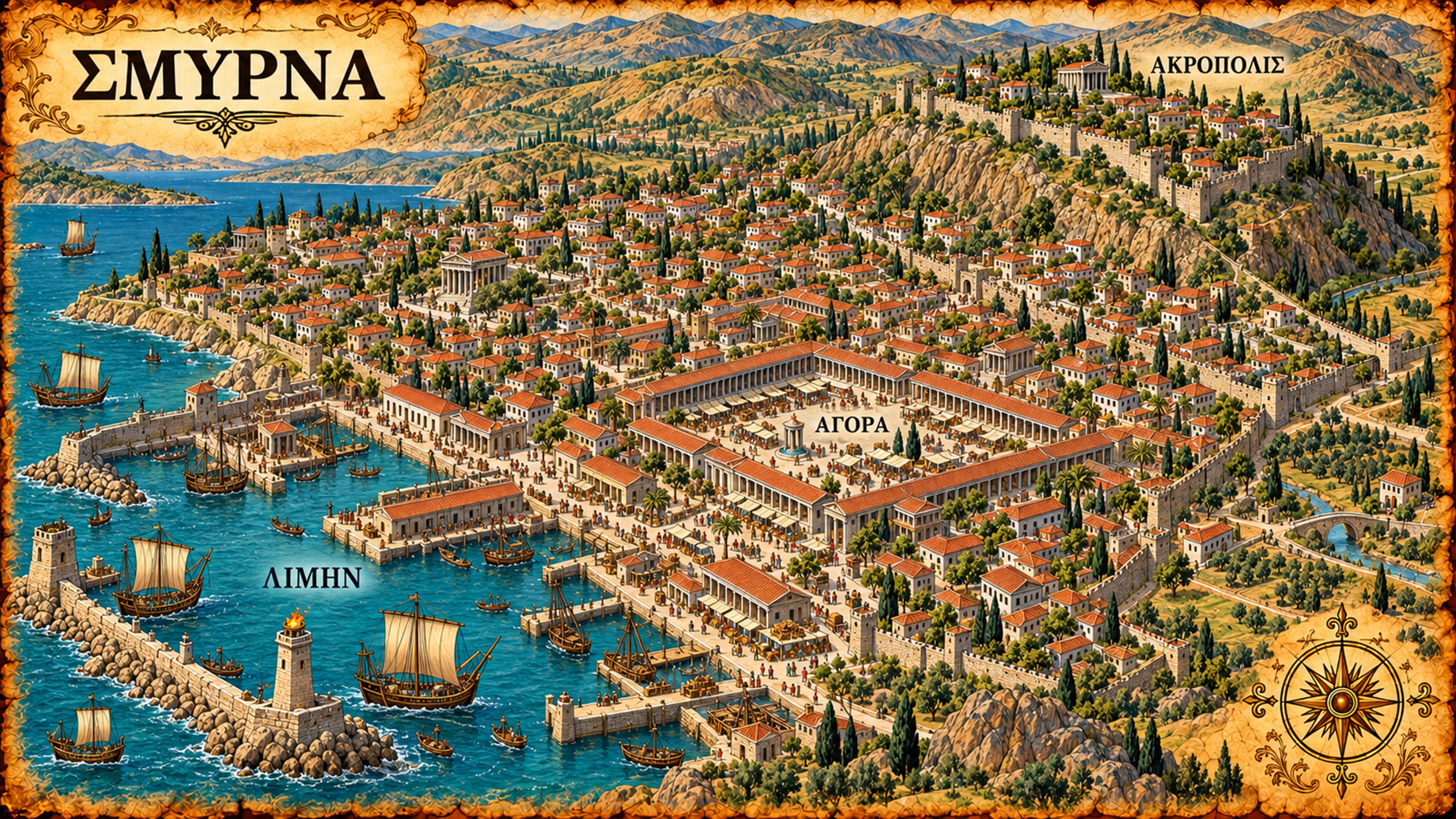
Smyrna ran from the harbor up to its upper city. The geographer Strabo describes the city spread across the plain by the harbor and up a fortified hill, with straight paved streets and large two-story porticoes. The map follows that description: ships and quays at the bottom, the town in the middle, and the high ground above.
The agora was the public square and marketplace. The map fills it with stalls, goods, and people under long covered colonnades.
Look closely. Follow the climb from the harbor, through the market, to the upper city.
| ΣΜΥΡΝΑ | Smyrna |
| ΛΙΜΗΝ | Harbor |
| ΑΓΟΡΑ | Agora — public square and marketplace |
| ΑΚΡΟΠΟΛΙΣ | Acropolis — upper or fortified city |
An agora served as a public meeting place as well as a center of trade.
Pergamum
A city above the plain / Revelation 2:12–17
 Full size
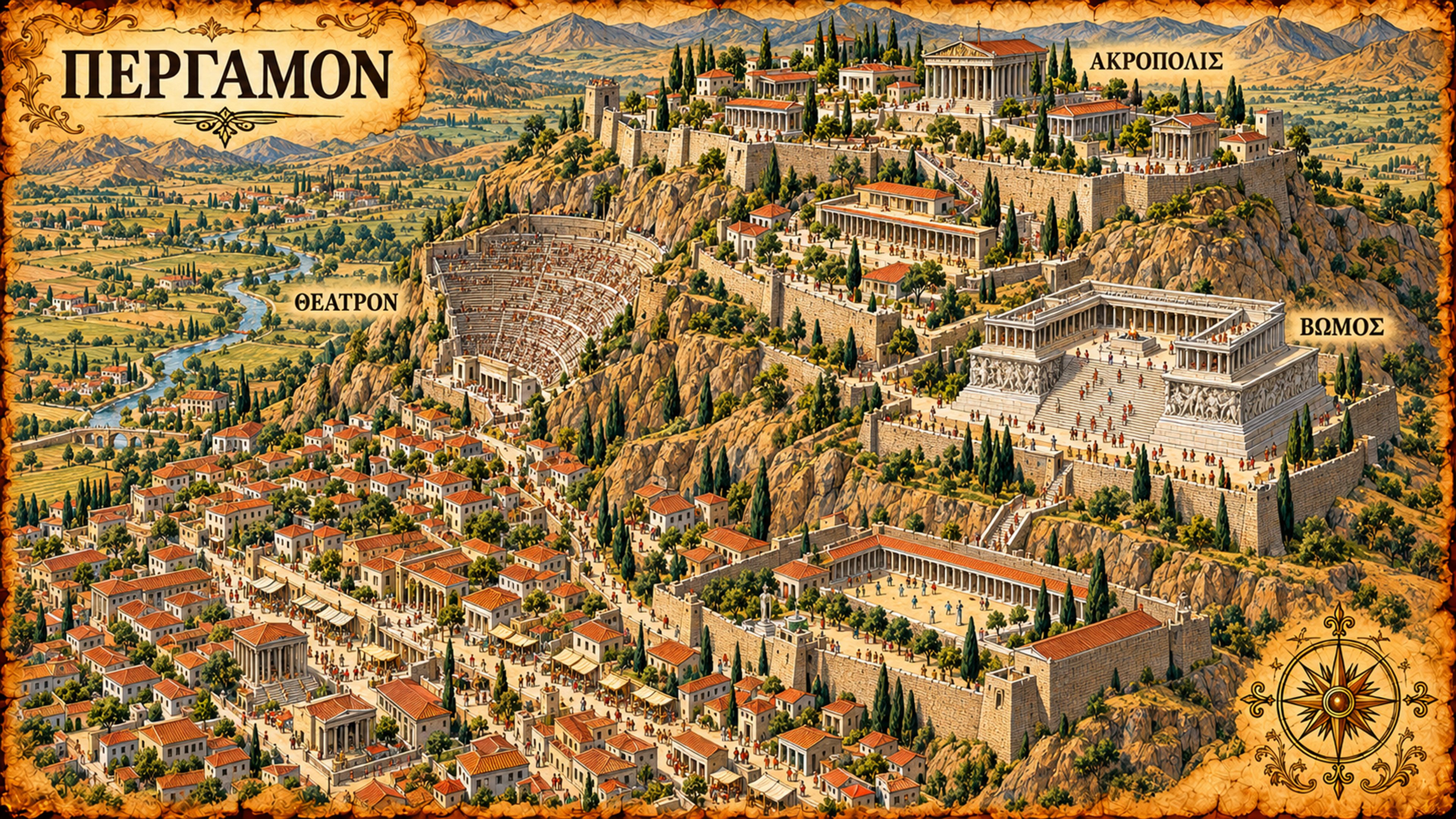
Pergamum was built on a steep hill. Its buildings stand on terraces cut into the slope, joined by stairs and held up by great retaining walls. The theater is built down the hillside, and the acropolis at the top looks out over the plain. This is the city's Hellenistic plan.
The Great Altar stood in its own precinct on a separate terrace, reached by a broad staircase. Pergamum also had the first temple in Asia to a living Roman ruler, and the sanctuary of Asklepios, the healing god whose emblem was a serpent.
Look closely. Find the theater going down the hillside, and the altar precinct on its own terrace.
| ΠΕΡΓΑΜΟΝ | Pergamum — also called Pergamon |
| ΑΚΡΟΠΟΛΙΣ | Acropolis — upper or fortified city |
| ΘΕΑΤΡΟΝ | Theater |
| ΒΩΜΟΣ | Altar |
ΒΩΜΟΣ identifies the pictured altar. Was this Revelation's "Satan's throne?"
Thyatira
The working city / Revelation 2:18–29; Acts 16:14
 Full size
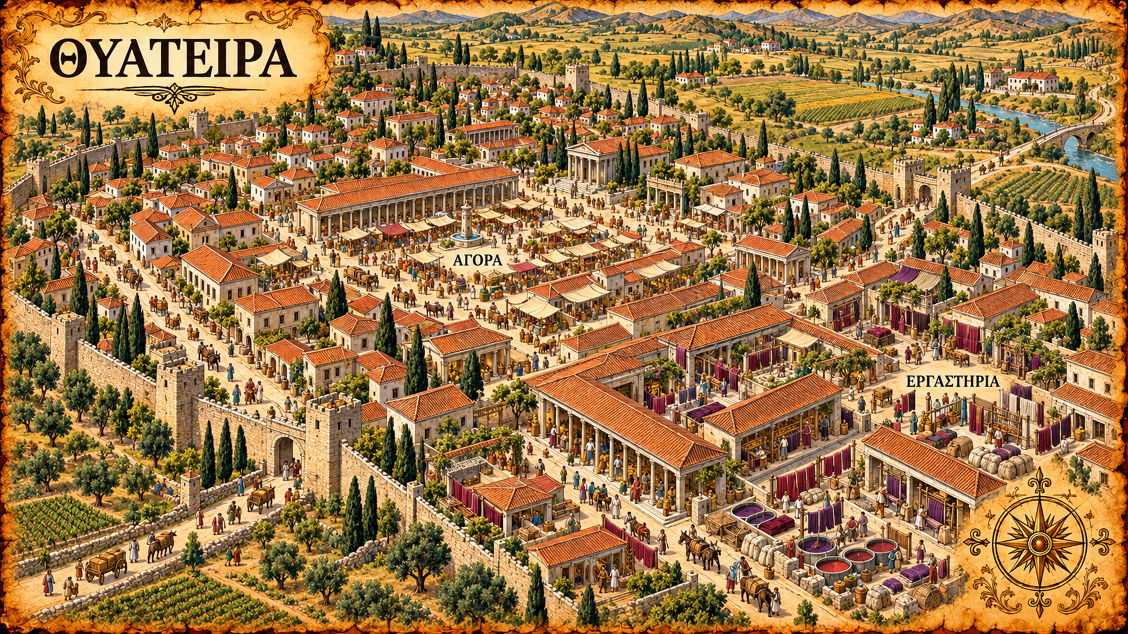
Thyatira was a working town. The map shows cloth hanging in courtyards, dye vats beside the work areas, and carts taking goods to market. The city stood on the roads between Pergamum, Sardis, and the interior, and excavation shows a Roman town full of weaving, dyeing, and organized trades.
Lydia, the seller of purple cloth whom Paul met at Philippi, came from Thyatira (Acts 16:14). The colored cloth on the map is the kind of trade her home city was known for.
Look closely. Look past the main square into the courtyards: the hanging cloth, the work spaces, and the carts.
| ΘΥΑΤΕΙΡΑ | Thyatira |
| ΑΓΟΡΑ | Agora — public square and marketplace |
| ΕΡΓΑΣΤΗΡΙΑ | Workshops |
ΕΡΓΑΣΤΗΡΙΑ is plural: places where people carry out their crafts.
Sardis
Beneath the citadel / Revelation 3:1–6
 Full size
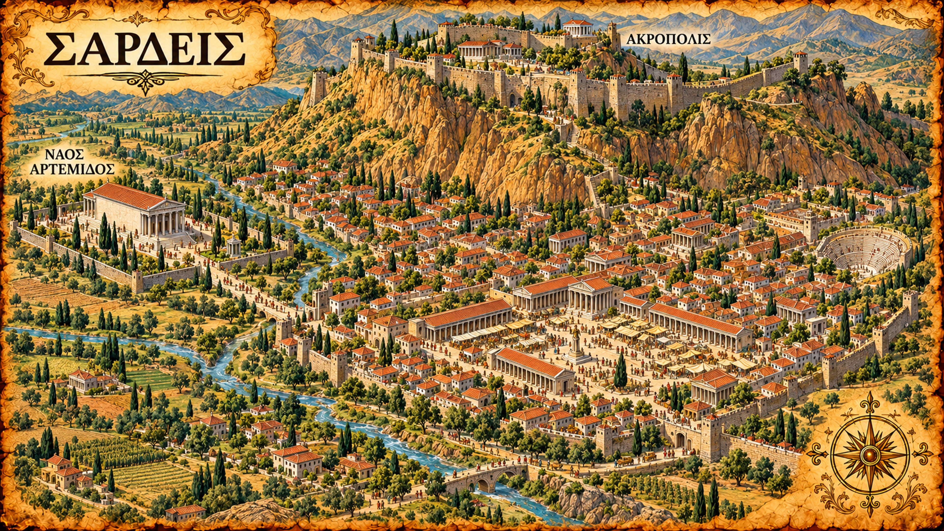
Sardis sat below a high citadel. Cliffs rise over the lower town, and the valley and its river lead out to the countryside. Strabo describes the city by its stronghold and the Pactolus River.
The sanctuary of Artemis stands apart from the crowded streets. The map shows the temple as it stood in the first century: a large roofed building with solid side walls and porches at each end.
Look closely. Compare the walled temple building with the open colonnaded squares in town.
| ΣΑΡΔΕΙΣ | Sardis |
| ΑΚΡΟΠΟΛΙΣ | Acropolis — upper or fortified city |
| ΝΑΟΣ ΑΡΤΕΜΙΔΟΣ | Temple of Artemis |
Sardis and Ephesus each had a sanctuary of Artemis; the identical Greek label names a different temple in each city.
Philadelphia
Town and countryside / Revelation 3:7–13
 Full size
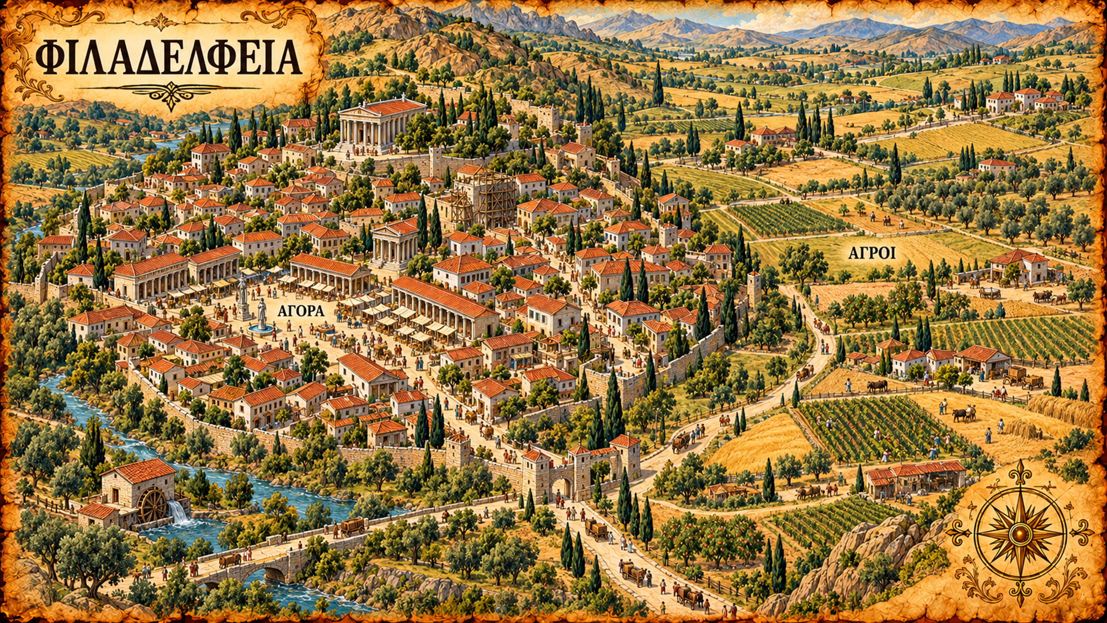
Philadelphia was a farm town. Roads run from the town out to the fields and to houses scattered across the countryside. Strabo describes the rich soil there and says many people lived outside the city because of the frequent earthquakes. The farms and the small repairs on the map come from that description.
Much of the town's life happened beyond its main square: work in the fields, produce moving along the roads, and households living off the land. The vineyard rows stand for the wine country Strabo describes next door.
Look closely. Follow the road out of town into the fields and farmsteads.
| ΦΙΛΑΔΕΛΦΕΙΑ | Philadelphia |
| ΑΓΟΡΑ | Agora — public square and marketplace |
| ΑΓΡΟΙ | Fields — cultivated countryside |
ΑΓΡΟΙ is plural. The label draws attention to the farmland surrounding the town.
Laodicea
Wealth woven into the city / Revelation 3:14–22
 Full size
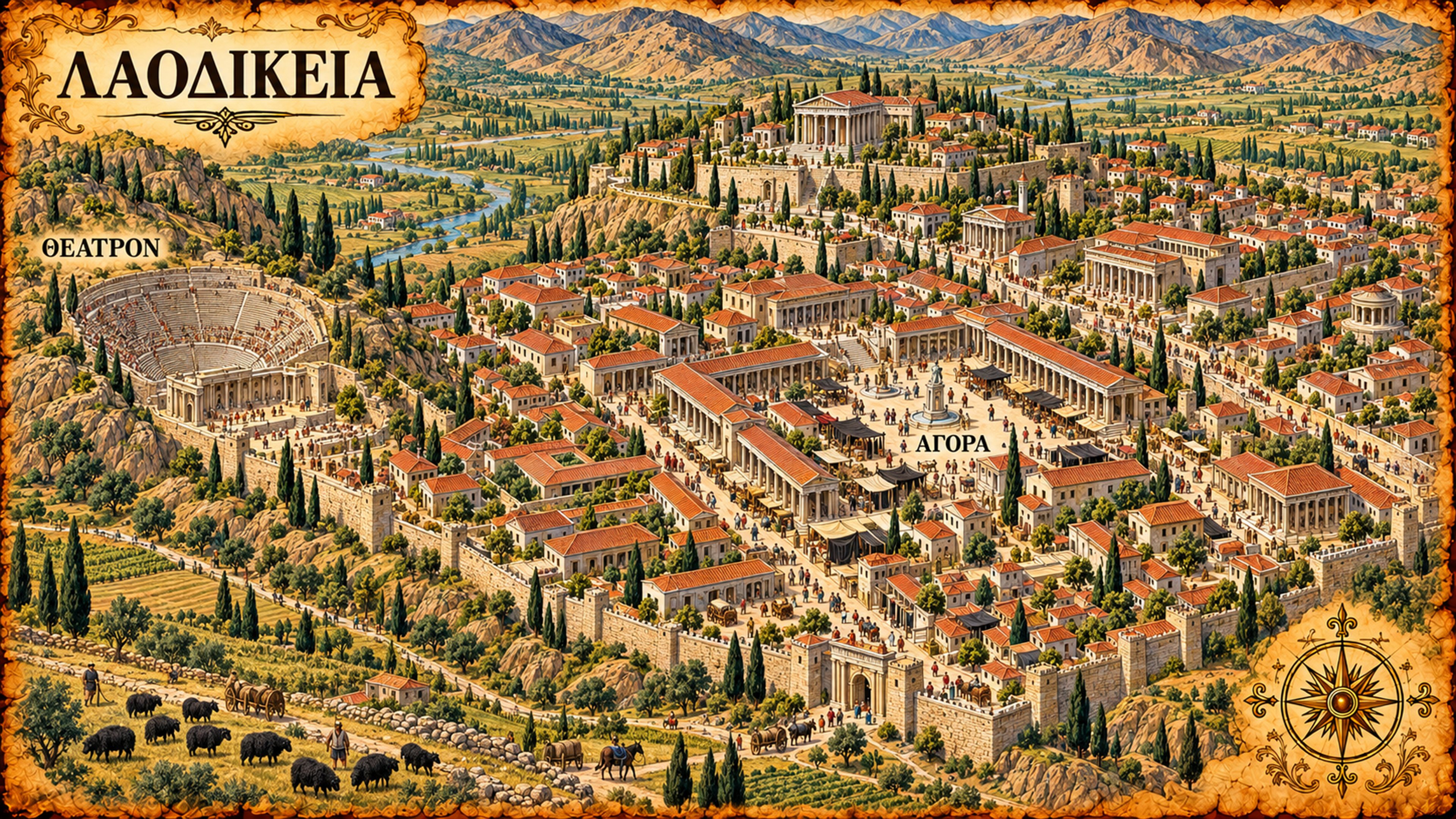
Laodicea was a wealthy city. The map shows pale stone buildings and busy public spaces, and in the foreground, dark-fleeced sheep and dark cloth. Strabo describes the area's soft black wool and the money it brought the Laodiceans.
The theater and the market are in town. The western theater was built in the Hellenistic period and altered in the early Roman period; the map gives an impression of the earlier building. The buildings, merchants, cloth, and flocks show the wealth around the church that received Revelation's seventh letter.
Look closely. Find the black sheep and the dark cloth. They point to the trade that made the city rich.
| ΛΑΟΔΙΚΕΙΑ | Laodicea |
| ΘΕΑΤΡΟΝ | Theater |
| ΑΓΟΡΑ | Agora — public square and marketplace |
The labels identify the city's public places; the dark wool supplies an additional visual clue to its economic life.
Printable pages
Each map with its write-up and Greek key, as one picture you can save or share.
The journeyPicture / JPGEphesusPicture / JPGSmyrnaPicture / JPGPergamumPicture / JPGThyatiraPicture / JPGSardisPicture / JPGPhiladelphiaPicture / JPGLaodiceaPicture / JPGAbout the maps and sources
These maps picture living cities in the course's first-century, pre-AD-70 setting. Their landmarks and defining features draw on historical evidence, while scale, terrain, street plans, and many everyday details are artistic reconstructions. Exact house, workshop, farm, wall, and tower locations are illustrative. Philadelphia's watermill is a background invention; Laodicea's slopes are exaggerated. The regional line represents the sequence of the letters and is not a surveyed ancient road. This companion preserves the maps as delivered.
The label keys reproduce the maps' unaccented uppercase Greek. Lexical checks for the map series used the Gingrich and abridged Liddell–Scott lexicons, as recorded in koine-prompts.md, the city prompts, and the accepted visual briefs. The explanations of agora and acropolis supply their relevant senses in these pictures. No modern church buildings are being identified.
- Ephesus: UNESCO, Ephesus. harbor setting, urban development, and Artemis sanctuary. Acts 19:24–29 supplies the shrine trade and theater episode.
- Smyrna: Strabo, Geography 14.1.37. harbor plain, fortified upper settlement, streets, and porticoes. The market's exact plan is illustrative.
- Pergamum: UNESCO, Pergamon. Hellenistic terraces, acropolis, theater, and Great Altar.
- Thyatira: Dokuz Eylül University excavation account. routes, crafts, and associations. This account spans the Roman period; it does not establish an excavated pre-70 workshop district. Acts 16:14 identifies Lydia's home city and trade.
- Sardis geography: Strabo, Geography 13.4.5. citadel, mountain, and river setting.
- Sardis temple: Sardis Expedition, The Temple of Artemis: Introduction. functioning Hellenistic cella and later imperial work on the surrounding colonnades.
- Philadelphia: Strabo, Geography 13.4.10–11. earthquakes, fertile countryside, rural habitation, and the neighboring Catacecaumene wine country. Vineyard placement and the pictured repairs are artistic inferences.
- Laodicea wool: Strabo, Geography 12.8.16. prosperous city and profitable soft black wool.
- Laodicea theater: Laodikeia excavation project, Western Theater. Hellenistic origins and subsequent Roman alterations. The image gives an early-period impression, not an exact reconstruction of every surviving feature.